Richland Creek Wilderness is truly one of the crown jewels of The Natural State. The wilderness comprises pristine streams, scenic bluff overlooks, waterfalls, unique sandstone rock formations.
Created in 1984 by the Arkansas Wilderness Act, the 11,801-acre tract is one of three wilderness areas within the Buffalo Ranger District, and it's featured in wildlife photographer Tim Ernst's hiking and photo books. And yet the area does not receive as many visitors as other nature reserves in the state.
For this reason — plus the fact that I am always looking for an excuse to explore this rugged wilderness — on a recent unseasonably warm and sunny winter morning, I volunteered to lead hikers from the NWA Hiking Meetup group on a Richland Creek Wilderness adventure.
OFF WE GO
With limited parking available at the trailheads I planned to use, we met at the Lurton-Pelsor Fire Department just off Arkansas 7, Arkansas' first scenic byway, where we loaded into as few vehicles as possible to head out to our first destination, Sandstone Castle.
To reach the trailhead, we drove east on Arkansas 123 for 1.6 miles and turned right on Newton County 5070. After 6.8 miles on this gravel road, we veered right onto NC 5080 to continue for another 1.1 miles.
The parking area, on the left, was little more than a wide spot in the road. Since wilderness areas do not allow construction of developed trails, we began our hike on a long-ago abandoned trace road, located directly across from the parking.
For those unfamiliar with the area, the location is easy to find because this is also the only section of the road where the utility line crosses overhead.
This being "leaf off," we were able to follow the faint path of an unofficial social trail. During spring and summer, hikers can use GPS coordinates (see accompanying UTM coordinates) and an electronic navigation device to bushwhack their own route to the Sandstone Castle.
Or better yet, experienced hikers could leave the gadgets at home. I have fond memories of adventures when my friend Bill Steward and I navigated with only a map and compass, at a time before anyone had published the locations of features like Sandstone Castle. We would study contour lines on the map, pick likely looking spots for scenic natural wonders and go exploring.
En route to the Castle, the Meetup group spotted a couple of nicely preserved rock walls. Since they did not extend to form a fenced enclosure, the consensus was these rocks had been collected to clear an area for a garden or to plow a field. This theory was reinforced after we passed the first of these rock walls and identified a stack of crumpled stones that had once been a chimney for a homesite.
Approximately 2.5 miles into our hike, we passed a scenic overlook atop a tall, sheer bluff that provided an encompassing view deep into the Richland Creek drainage.
Continuing farther along the social path (those who visit when a path is not visible should follow the bluff line to the right), we discovered a collapsed section of the bluff that provided a safe route to scramble down.
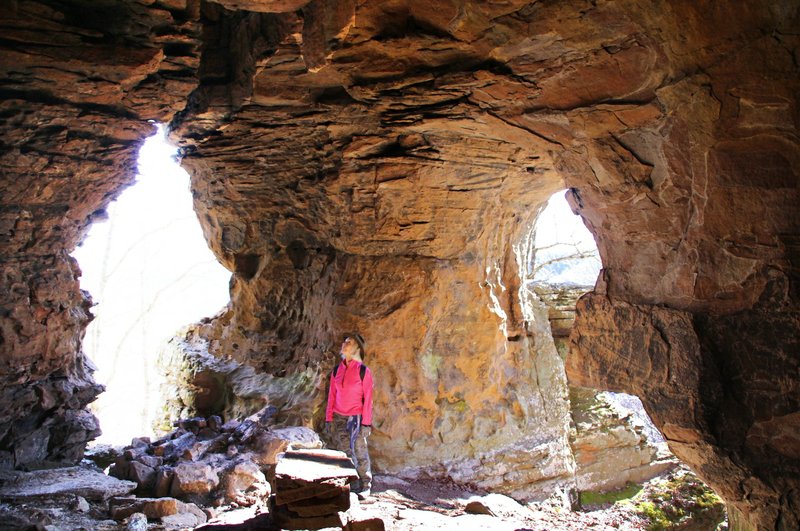
We had arrived at Sandstone Castle.
[Gallery not loading above? Click here for more photos » arkansasonline.com/galleries/28401/album/]
CASTLE IN THE SKY
Over the centuries, these sandstone walls have been carved by water, wind, freezing weather and other acts of nature to create spacious cavities deep in the hillside.
The Castle consists of several large rooms, including one with a large stone pillar standing guard at its entrance. There are also openings higher up the bluff that the more adventurous of the group climbed to for further investigation.
I have read tales of Civil War deserters who hid within these caves after they abandoned the cause. As I stood at one of the openings, peering across the surrounding tranquil forest and the picturesque drainage below, it was easy to believe a weary warrior would have found the shelter inviting.
Our group found the setting so inviting we decided to perch at one of the jagged openings for a midmorning snack while admiring the window it offered into the drainage below.
On earlier visits to the Castle, I had always made a point to drop down the hillside into the east drainage, Big Devil's Fork, to investigate a pair of large old grist millstones. I enjoyed visualizing the scene when the mill was perched on the banks of the nearby falls, and these same stone wheels steadily ground corn for surrounding homesteaders.
However, the millstones are no longer there.
Yep, sad but true — gone!
Ernst told me he had seen a program on television, either American Pickers on the History channel or a comparable show, featuring similar millstones and stating how valuable they were. The next time he hiked into the area, the stones were gone.
ONWARD TO TWIN FALLS
The adventure continued as we left the Castle bluff behind to venture onward to our next adventure, Twin Falls.
Even if there had been no visible social path or we didn't have GPS, it would have been easy to navigate to the falls. When reaching the easternmost Castle room all we would have to do was drop down the backbone of the ridge and then, by keeping Big Devil's Fork to our left and Long Devil's Fork to our right, after approximately a mile of hiking, we would have arrived at a unique natural feature in the Ozark Mountains.
Standing on a ledge, centered between a pair of 20-foot falls that roar a meager 25 feet apart, in my experience, is a rare experience. Normally, a pair of waterfalls so close together would be created when an island split a single waterway. However, here, each of the falls is being fed by two separate drainage systems.
The view from the centered ledge is truly majestic, especially during high water periods, with the turbulence cascading over the pair of bluffs to crash onto the rocky creek bed below.
But I believe the best view is at the base of the falls.
The easiest route that I have found to reach the base of these falls is by crossing Long Devil's Fork, the waterway to the right as you face the falls. Once across the stream, there is what appears to have been a trace road with switchbacks up the hillside a short distance, providing passage above the steep walls bordering the falls themselves, then drops back down to the base of the falls.
Use great caution when crossing the stream. The polished rock can be very slick, and if you fall, the force of the rushing water could sweep you over the falls to a damaging landing.
Our group of explorers enjoyed a long respite in the setting of this beautiful natural wonder, with no one being eager to begin the challenging ascent on our return hike.
A VISIT WITH EFFIE
In the shortened daylight of winter, we did not have time to visit more of the many other waterfalls and vistas within the Richland Creek Wilderness. However, for me, no excursion there would be complete without a visit to the gravesite of Effie D. Eveleigh, a long ago resident of the area.
After returning to the trailhead, we resumed our drive on Newton County 5080 for another 2.4 miles to then turn left on NC 5085. After another 3.8 miles, we reached the entrance to the parking lot of the Stack Rock "special interest area."
Note: Do not mistakenly turn into the parking lot for the Ozark Highland Trail Stack Rock Trailhead, which you will pass en route.
Less than a quarter of a mile after turning off NC 5085, we parked in a small clearing. Our hike then began through an opening in a fence that bordered the parking area.
At one time, the Forest Service maintained a hiking trail to Stack Rock Mountain that also included a walk-in camp area. I believe this had been constructed primarily to be used by rock climbers.
However, since a storm toppled several trees, the trail and the camp area have been pretty much abandoned.
By following another faint social trail, along with several remaining yellow-diamond blazes from the original trail, after less than a mile, we arrived at the base of Stack Rock Mountain.
Upon reaching the sheer, 30- to 40-foot bluff that encircles the mountain, we continued to follow the bluff line to our right until we reached a fracture in the wall of rock that provides, at least as far as I have found, the only passageway to the mountain's plateau.
After cresting the top of the bluff, we had to hike up yet another steep hillside before arriving at the summit. At this point, we stayed on the northern side of the mountaintop to avoid the worst of the dense briers that normally stand guard over the approach to the gravesite.
I have debated whether to provide specific directions to reach the headstone, not wanting to expose it to vandals. However, in the end, I decided that anyone willing to make the strenuous trek up the mountain and brave the dense briers would possess the character to show Effie proper respect.
Whenever I visit Effie's headstone, I am impressed by her husband, William, hauling this beautiful, heavy monument up the steep mountainside to provide Effie an awesome view for eternity. If actions speak louder than words, William expressed his love for Effie far more sincerely than words ever could.
I trust that every visitor will show proper respect for this testimony to love and not disturb the memorial.
And while you are there, tell Effie that Bob said, "Hello."
Here are Universal Transverse Mercator coordinates for use in the Richland Creek Wilderness Area.
◼️ Sandstone Castle (UTM 502416E, 3963626N)
◼️ Twin Falls (UTM 503261E, 3962202N)
◼️ Passage up Stack Rock (UTM 508224E, 3970971N)
Bob Robinson is the author of Bicycling Guide to the Mississippi River Trail, Bicycling Guide to Route 66 and Bicycling Guide to the Lake Michigan Trail (spiritscreek.com).
Style on 01/20/2020